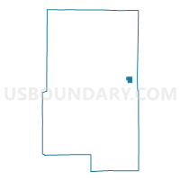
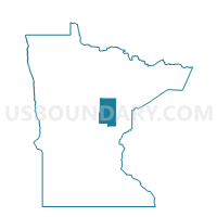
Tamarack Voting District, Aitkin County, Minnesota
About
Outline

Summary
| Unique Area Identifier | 600926 |
| Name | Tamarack Voting District |
| County | Aitkin County |
| State | Minnesota |
| Area (square miles) | 3.58 |
| Land Area (square miles) | 3.58 |
| Water Area (square miles) | 0.00 |
| % of Land Area | 100.00 |
| % of Water Area | 0.00 |
| Latitude of the Internal Point | 46.65284620 |
| Longtitude of the Internal Point | -93.12528210 |
Maps

Graphs
Select a template below for downloading or customizing gragh for Tamarack Voting District, Aitkin County, Minnesota